Forecast sea level change by 2050
Material recently published by the CRD predicts that in 35 years Island View Beach will be permanently under sea water, so flooding will be a routine thing for years before that if no action is taken.
The question that must now override all else is whether to save Island View Beach or not. What good is a park plan when there is no park?
The issue is more complex than just Island View Beach Regional Park, for that is only one parcel of the flat lands - the other parcels being farm land; residential land with housing; the Central Saanich Park; and the Tsawout lands.
The following material is taken from
Capital Regional District
Coastal Sea Level Rise Risk Assessment
Prepared by: AECOM
200 – 415 Gorge Road East
Victoria, BC, Canada
V8T 2W1
www.aecom.com
January 2015 See here to download the full report
"2.2.3.1 Sea Level Rise [from page 8 of the Aecom report above]
Based on guidance from the MFLNRO Coastal Floodplain Mapping Guidelines and Specifications, the following SLR scenarios were developed for the inundation mapping in the CRD study area:
• 0.5 m increase by 2050.
• 1.0 m increase by 2100.
• 2.0 m increase by 2200. "
"2.2.3.2 Storm Surge [from page 9 of the Aecom report above]
Taking into account the influence of storms on coastal water levels, the MFLNRO Coastal Floodplain Mapping Guidelines and Specifications provides recommendations for incorporating appropriate storm surge scenarios in the determination of design water levels. For highly developed areas of British Columbia such as Victoria, a 500-year (0.2-percent annual chance) magnitude storm surge of 1.3 m is recommended based on work by Ausensco Sandwell (2011a, b). This amount of storm surge was added to the future HHWLT water level to obtain an additional set of extreme tide scenarios considering the influence of storm events on coastal inundation. "
"2.2.3.3 Wave effects [from page 9 of the Aecom report above]
The presence of breaking wave conditions may further increase the depth of water near the shoreline and will result in wave runup, potentially resulting in erosion and flooding. The extent of flooding will depend on terrain located landward of the shoreline. Wave effects were not included in the analysis, but the MFLNRO Coastal Floodplain Mapping Guidelines provides recommendations for estimating an allowance for wave effects. "
HHWLT = average annual high tide
HHWLT plus storm surge = extreme high tide
[from page 10 of the Aecom report above]
Table 4 - Future Projections of HHWLT and Extreme High Tide for the CRD Study Area
[from page 10 of the Aecom report above]
Showing only Zone 3 for the Island View Beach area
(including vertical land movement and sea level rise)
Estimated Future HHWLT Estimated Future Extreme High Tide
Existing 2050 2100 2200 Existing 2050 2100 2200
1.5 1.95 2.39 3.28 2.8 3.25 3.69 4.58
Note 1: Future water levels include global SLR projections with local adjustments for vertical land motion at 2050, 2100, and 2200, as described in Section 2.2.3.1 (Table 3). Allowance for regional uplift or subsidence for each time period was calculated using vertical land movement values taken from Table 3. The formula is as follows: Allowance for Regional Uplift or Subsidence = Vertical Land Movement x (-1). Example calculation: Zone 1 (2050) = Existing HHWLT (1.9 m) + Subsidence (-0.02 * -1) + Sea Level Rise (0.50 m) = 2.42 m. Subsidence values increase the amount of relative sea level rise; uplift values decrease the amount of relative sea level rise. The extreme tide scenarios include a 500-year storm surge magnitude of 1.3 m.. Note 2: The Canadian Hydrographic Service is in the process of updating local luni-tidal based HHWLT estimates, which are consistent with provincial sea level rise mapping guidelines and used in this study, to values established using a new datum calculator program.”
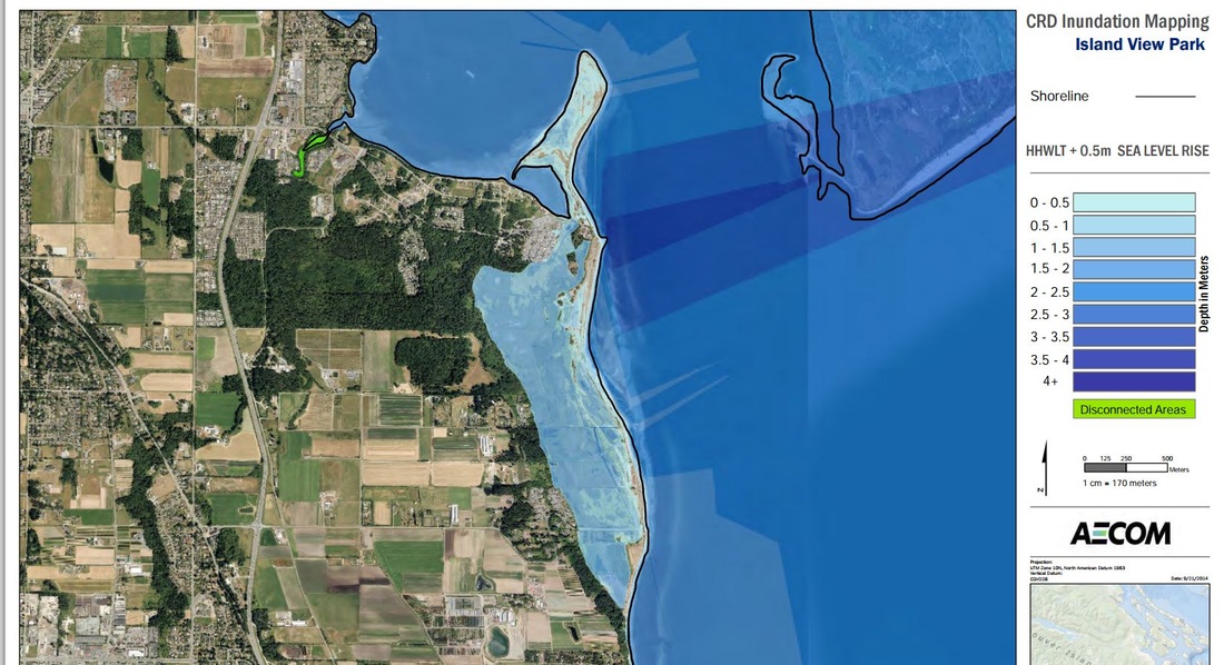
The map following was taken from
Capital Regional District
Inundation Mapping
by AECOM to see the whole document click here
This map shows the CRD's forecast flooding of Island View Beach with a .5m rise in sea level in 35 years (by 2050)
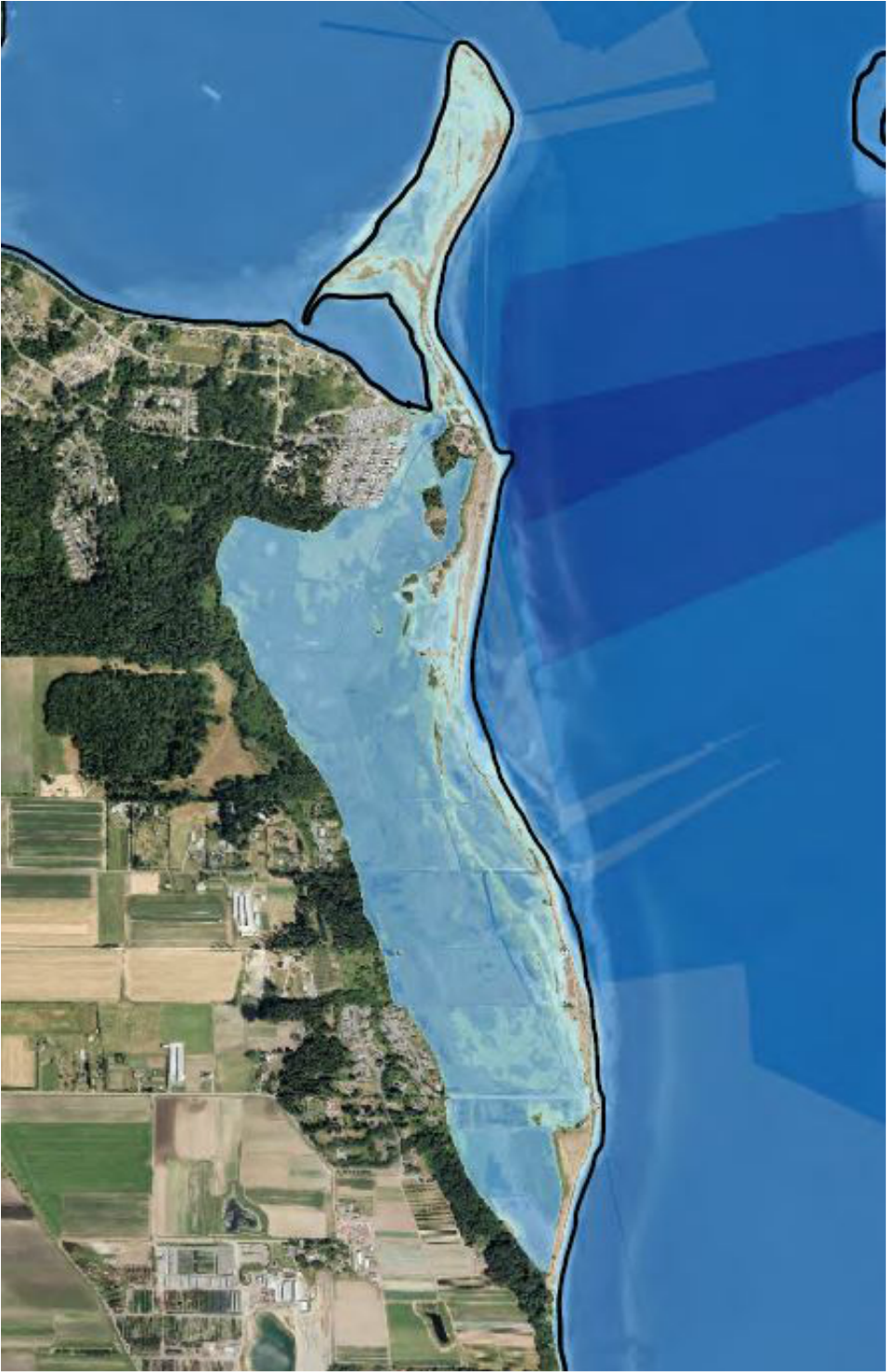
This is an expanded view of the area that the CRD forecast will be inundated by 2050
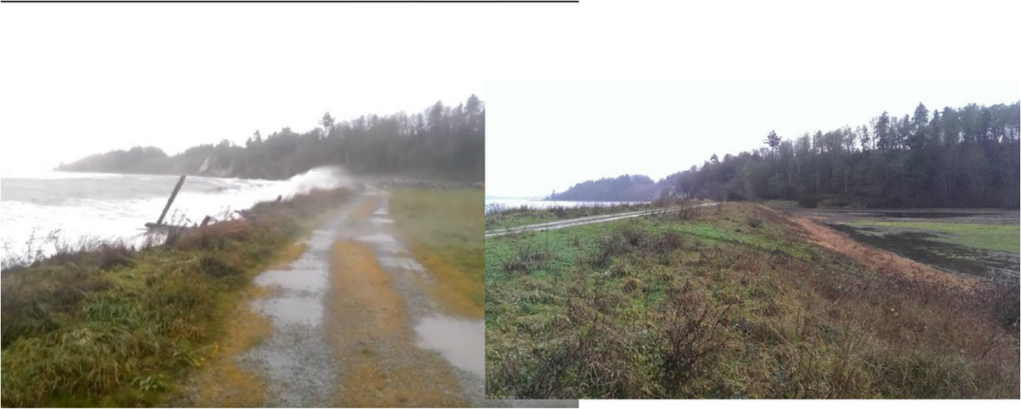
The photo on the left below is a screen grab of a video of a storm on December 5, 2015, breaking over the top of the sea wall on the private land to the south of Island View Road. The photo to the right shows the back side of that sea wall. At the time of the storm, the sea was approximately 2m higher than the flat land behind the sea wall.
That flat land extends all the way to the north, including the CRD Park and the Tsawout lands. There are 5 owners of the sea wall but there is no coordinated plan to maintain the sea wall. If the sea wall/berm fails at any one place it will flood the lands of all.
This video shows how close Island View Beach is to being flooded in 2015, and the likelihood it will be flooded long before 2050 unless coordinated action is taken to protect it.
To see the storm video of December 5, 2015 click here
1. CRD staff were cautioned by the Ministry of Enviroment, Stacey Filatow 2009 report, at page 17:
"Sea level rise due to global warming may threaten the ecosystems …. It is important to integrate climate change into management considerations …”
2. In addition, the Friends of Island View Beach urged the CRD repeatedly through 2015 of the critical importance to inform the public of the forecast that the park will be under sea level in a short time.
3. And the CRD itself identifies climate change as a strategic priority and says:
The climate is changing. Scientists project that the capital region will experience:
• A shift in annual weather patterns
• More extreme precipitation events
• An increase in extreme temperatures with hotter, drier summers
• More frequent and intense rain and wind storms
• Sea level rise
Without action, these changes threaten a variety of regional and local government services, as well as overall community health and wellbeing. The CRD needs to anticipate and prepare for these changes.
Despite all this, the CRD Environmental assessment of January 2015 failed to tell the public of the forecasts that Island View Beach will be under water in 2050. Had they done so, this would almost certainly have changed the public's opinions for the future of the park.