The natural state of the Island View Beach flat lands
The great salt marsh myth
For something like 25 years, the flapper gate on the north drainage system has been open, allowing sea water to flow freely up the ditch system and flood the southern part of the Tsawout flat lands, Puckle Farm, and the CRD park. It has gone on for so many years that the natural vegetation changed to that suitable for a salt water environment. Around 2005-2009 the CRD, Central Saanich and the Ministry of the Environment saw this salt water flooding and variously labeled it as a salt march and a "sensitive aquatic zone" without realizing it was man made.
In 2011 the open flapper gate was discovered by a member of the Island View Ditch & Mosquito Committee, and the CRD were informed this was not a natural salt marsh. In 2012 the Tsawout had a contractor make two attempts to fix the flapper gate. The gate is now locked in a closed position, but must be undermined because salt water still pours through and up the ditch system twice a day.
See more detail here
The question then arises - what was the natural state of this flat land before the failure of the flapper gate lead to this area being flooded twice daily with salt water?
Puckle Farm is relevant because records remain that describe those lands before major alteration by the settlors.
The dates of key changes were
The 1858 Trutch survey
The Saanich Peninsula was first surveyed in 1858 by John Trutch, brother of the well known politician, Joseph Trutch.
The survey used Mt Newton as a reference point, numbering to the south, and also to the east or west. The surveys were in 100 acre parcels, in a rectangular form, 20 chains by 50 chains. (A chain is 66 feet. 10 square chains = one acre.)
References: http://www.johndeanpark.com/post-no-1-of-survey-of-north-and-south-saanich-districts/
https://ltsa.ca/docs/Crown-Lands-A-History-of-Survey-Systems.pdf (page 7)
https://en.wikipedia.org/wiki/Chain_(unit)
Puckle Farm was two parcels, 100 acres plus the remaining 38 acres to the sea. The legal descriptions were Section 9, Range 5 East, and Section 9, Range 6 East, South Saanich District, meaning these parcels were 9 properties to the south of Mount Newtown, and 5 and 6 properties to the east respectively.
The Trutch survey can be seen here. The red lines were not part of the Trutch survey and have been added here to show the boundaries.
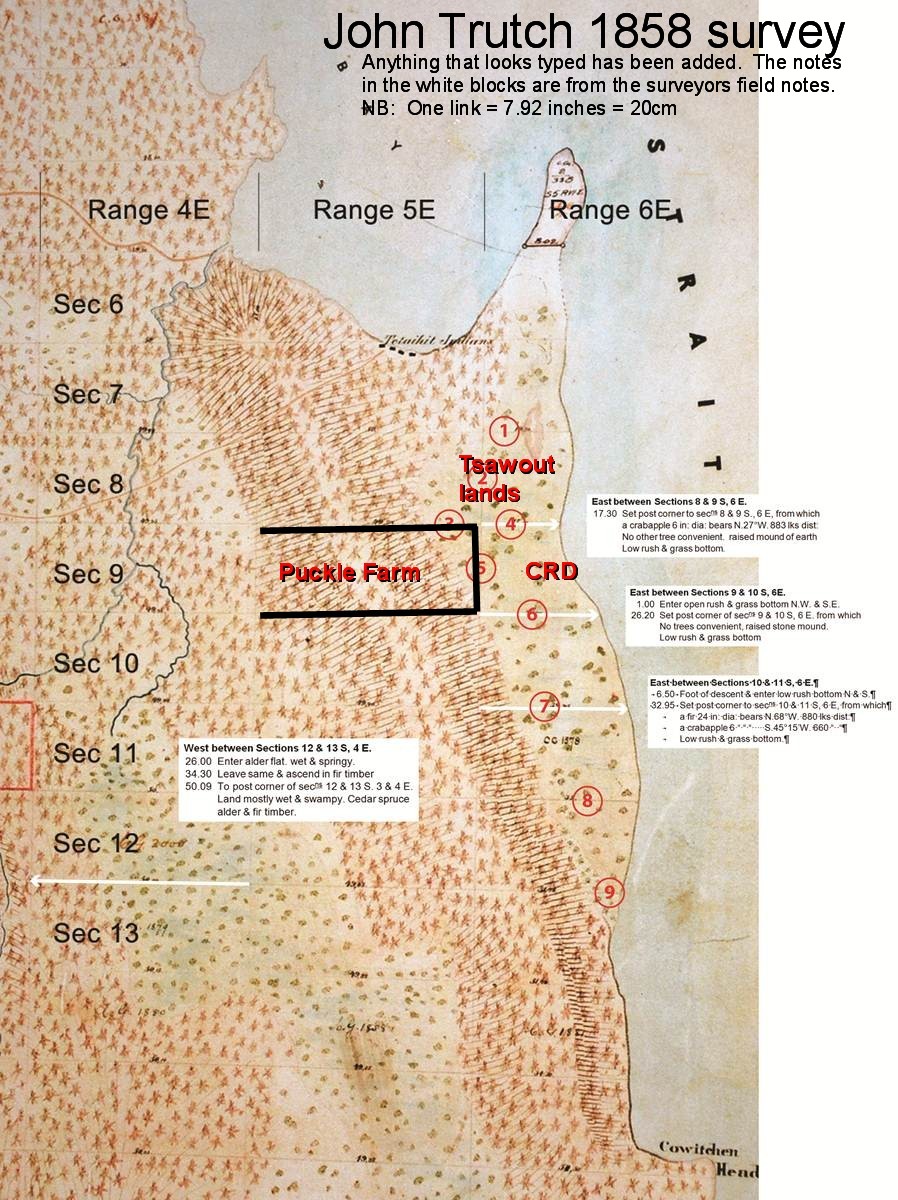
1858 survey: description of the flat lands - low rushes & grass, evidence of crabapple, no mention of wet ground.
The notebooks of the surveyor, John Trutch, have been transcribed by Central Saanich Councilor, Bob Thompson. Trutch made notes of the land conditions as he moved around.
Raised mound of earth. Low rush and grass bottom.
26.2 Set post corner of sec 9&10 S. 6E from which no trees convenient, raised stone mound.
Low rush and grass bottom.
It is significant that Trutch does not record wet or swampy ground, because it was his practice to do so. For example, on the west side of the ridge in what would now be the Michell farm fields, he recorded: "26.00 Enter alder flat, wet and springy. 34.3 Leave same and ascend in fir timber. 50.09 To post corner of sec's 12 & 13 S. 3 & 4 E. Land mostly wet & swampy. Cedar spruce alder & fir timber."
See the annotated Trutch 1858 survey here
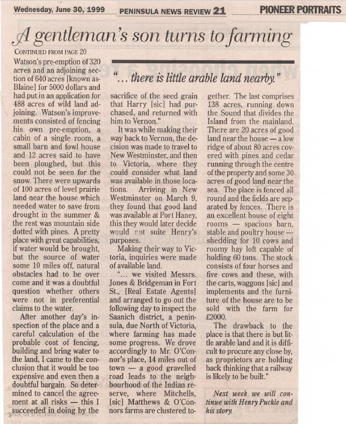
1892 purchase of the property - description of the flat lands as "30 acres of good land near the sea"
Richard Puckle assisted his son Henry to purchase Puckle Farm in 1892. In his description of the purchase of the 138 acres, he said it included "some 30 acres of good land near the sea". See here
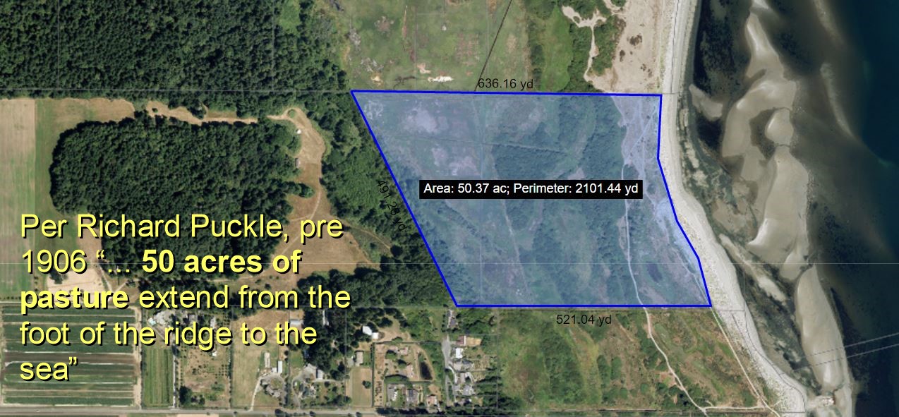
Undated, prior to 1906 "50 acres of pasture extend from the foot of the ridge to the sea" See article here See map here
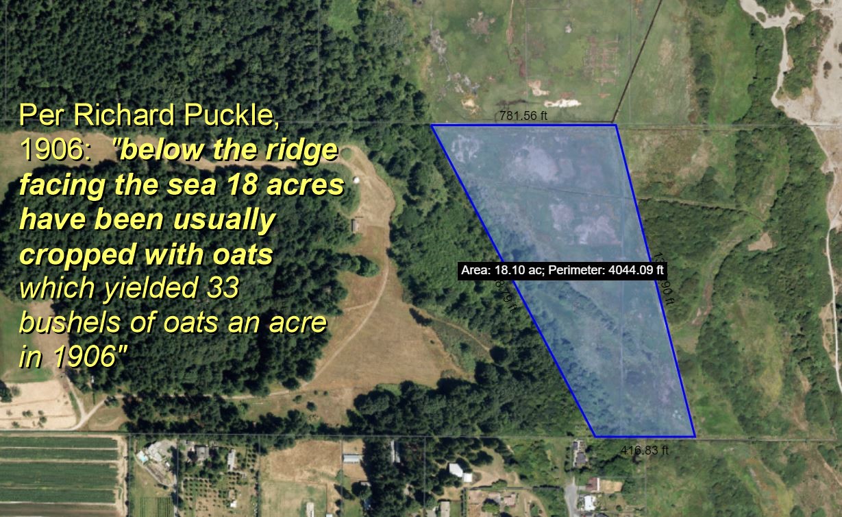
1906 "below the ridge facing the sea 18 acres have been usually cropped with oats which yielded 33 bushels of oats an acre in 1906". See article here See map here
For something like 25 years, the flapper gate on the north drainage system has been open, allowing sea water to flow freely up the ditch system and flood the southern part of the Tsawout flat lands, Puckle Farm, and the CRD park. It has gone on for so many years that the natural vegetation changed to that suitable for a salt water environment. Around 2005-2009 the CRD, Central Saanich and the Ministry of the Environment saw this salt water flooding and variously labeled it as a salt march and a "sensitive aquatic zone" without realizing it was man made.
In 2011 the open flapper gate was discovered by a member of the Island View Ditch & Mosquito Committee, and the CRD were informed this was not a natural salt marsh. In 2012 the Tsawout had a contractor make two attempts to fix the flapper gate. The gate is now locked in a closed position, but must be undermined because salt water still pours through and up the ditch system twice a day.
See more detail here
The question then arises - what was the natural state of this flat land before the failure of the flapper gate lead to this area being flooded twice daily with salt water?
Puckle Farm is relevant because records remain that describe those lands before major alteration by the settlors.
The dates of key changes were
- The First World War, where a simple drainage ditch was built on the Tsawout lands in order for the military to train - see here for the location of their barracks see aerial photo
- 1936 when a larger mosquito drainage system was built in the south.
The 1858 Trutch survey
The Saanich Peninsula was first surveyed in 1858 by John Trutch, brother of the well known politician, Joseph Trutch.
The survey used Mt Newton as a reference point, numbering to the south, and also to the east or west. The surveys were in 100 acre parcels, in a rectangular form, 20 chains by 50 chains. (A chain is 66 feet. 10 square chains = one acre.)
References: http://www.johndeanpark.com/post-no-1-of-survey-of-north-and-south-saanich-districts/
https://ltsa.ca/docs/Crown-Lands-A-History-of-Survey-Systems.pdf (page 7)
https://en.wikipedia.org/wiki/Chain_(unit)
Puckle Farm was two parcels, 100 acres plus the remaining 38 acres to the sea. The legal descriptions were Section 9, Range 5 East, and Section 9, Range 6 East, South Saanich District, meaning these parcels were 9 properties to the south of Mount Newtown, and 5 and 6 properties to the east respectively.
The Trutch survey can be seen here. The red lines were not part of the Trutch survey and have been added here to show the boundaries.
1858 survey: description of the flat lands - low rushes & grass, evidence of crabapple, no mention of wet ground.
The notebooks of the surveyor, John Trutch, have been transcribed by Central Saanich Councilor, Bob Thompson. Trutch made notes of the land conditions as he moved around.
- The northern point where Section 9 Range 5 East met Range 6 East (bordering on the Tsawout lands):
Raised mound of earth. Low rush and grass bottom.
- The southern point where Section 9 Range 5 East meets Range 6 East
26.2 Set post corner of sec 9&10 S. 6E from which no trees convenient, raised stone mound.
Low rush and grass bottom.
It is significant that Trutch does not record wet or swampy ground, because it was his practice to do so. For example, on the west side of the ridge in what would now be the Michell farm fields, he recorded: "26.00 Enter alder flat, wet and springy. 34.3 Leave same and ascend in fir timber. 50.09 To post corner of sec's 12 & 13 S. 3 & 4 E. Land mostly wet & swampy. Cedar spruce alder & fir timber."
See the annotated Trutch 1858 survey here
1892 purchase of the property - description of the flat lands as "30 acres of good land near the sea"
Richard Puckle assisted his son Henry to purchase Puckle Farm in 1892. In his description of the purchase of the 138 acres, he said it included "some 30 acres of good land near the sea". See here
Undated, prior to 1906 "50 acres of pasture extend from the foot of the ridge to the sea" See article here See map here
1906 "below the ridge facing the sea 18 acres have been usually cropped with oats which yielded 33 bushels of oats an acre in 1906". See article here See map here